Total solar eclipse · 12 August 2026 · Spain, coast to coast
Where to stand when the sun goes out
The umbra crosses mainland Spain in about six minutes, from the Asturias coast to the Ebro delta — 676 km of centreline in a band ~300 km wide. The sun is low the whole way and gets lower eastward, so terrain decides everything. 93 sites verified against 5 m LiDAR, tree canopy, building footprints and 20 years of cloud records.
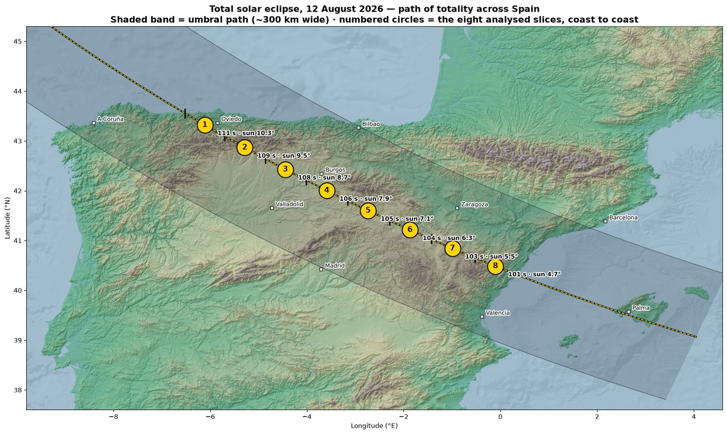
Go west for altitude, east for weather. Slice 1 has the longest totality (111 s) and the highest sun (10.3°) — and the Cantabrian coast is clouded out half the time. Slices 3 to 5 across the Castilian páramo are the compromise: 105–108 s, sun 7–9°, wide horizons and reliably clear August skies.
Everywhere, the sun sets while still eclipsed or immediately after. Look west-northwest — azimuth 281° at the Atlantic end swinging to 285° at the Mediterranean. The umbra runs almost due south, so the shadow arrives from your right as you face the sun.
The eight slices
West to east. Each opens its own page with every verified site, coordinates, aerial photos and forecast links.
At a glance
| Slice | Totality | Sun alt | Azimuth | Max (CEST) | Best site | Rating |
|---|---|---|---|---|---|---|
| Slice 1 — Asturias / Asturies | 111 s | 10.3° | 281° | 20:28 | Roadside nr. Quirós (south)43.1829, -5.9229 · Park at the spot | Excellent94 |
| Slice 2 — Asturias / Asturies → Palencia | 109 s | 9.5° | 281° | 20:28 | Roadside nr. Cangas de Onís43.2755, -5.0025 · Park at the spot (road) | Excellent94 |
| Slice 3 — Palencia → Burgos | 108 s | 8.7° | 282° | 20:29 | Redondilla42.6498, -4.2402 · Short walk 188 m (track) | Excellent91 |
| Slice 4 — Burgos → Soria | 106 s | 7.9° | 283° | 20:29 | Roadside nr. Tejada (south)41.9456, -3.5566 · Park at the spot | Excellent96 |
| Slice 5 — Soria | 105 s | 7.1° | 283° | 20:30 | El Ardal41.7616, -3.1288 · Park at the spot (track) | Excellent96 |
| Slice 6 — Soria → Teruel | 104 s | 6.3° | 284° | 20:30 | Cerro de Santa Cruz41.1142, -1.5656 · Park at the spot (track) | Excellent95 |
| Slice 7 — Teruel | 103 s | 5.5° | 285° | 20:31 | Roadside nr. Cuevas de Almudén40.7692, -0.8030 · Park at the spot (road) | Excellent95 |
| Slice 8 — Teruel → Castelló / Castellón | 101 s | 4.7° | 285° | 20:31 | Roadside nr. Fortanete40.5432, -0.5240 · Park at the spot (road) | Excellent95 |
Where August evenings are actually clear
↑ contentsTwenty years of the aerodromes' own METARs, counted in the hour totality falls.
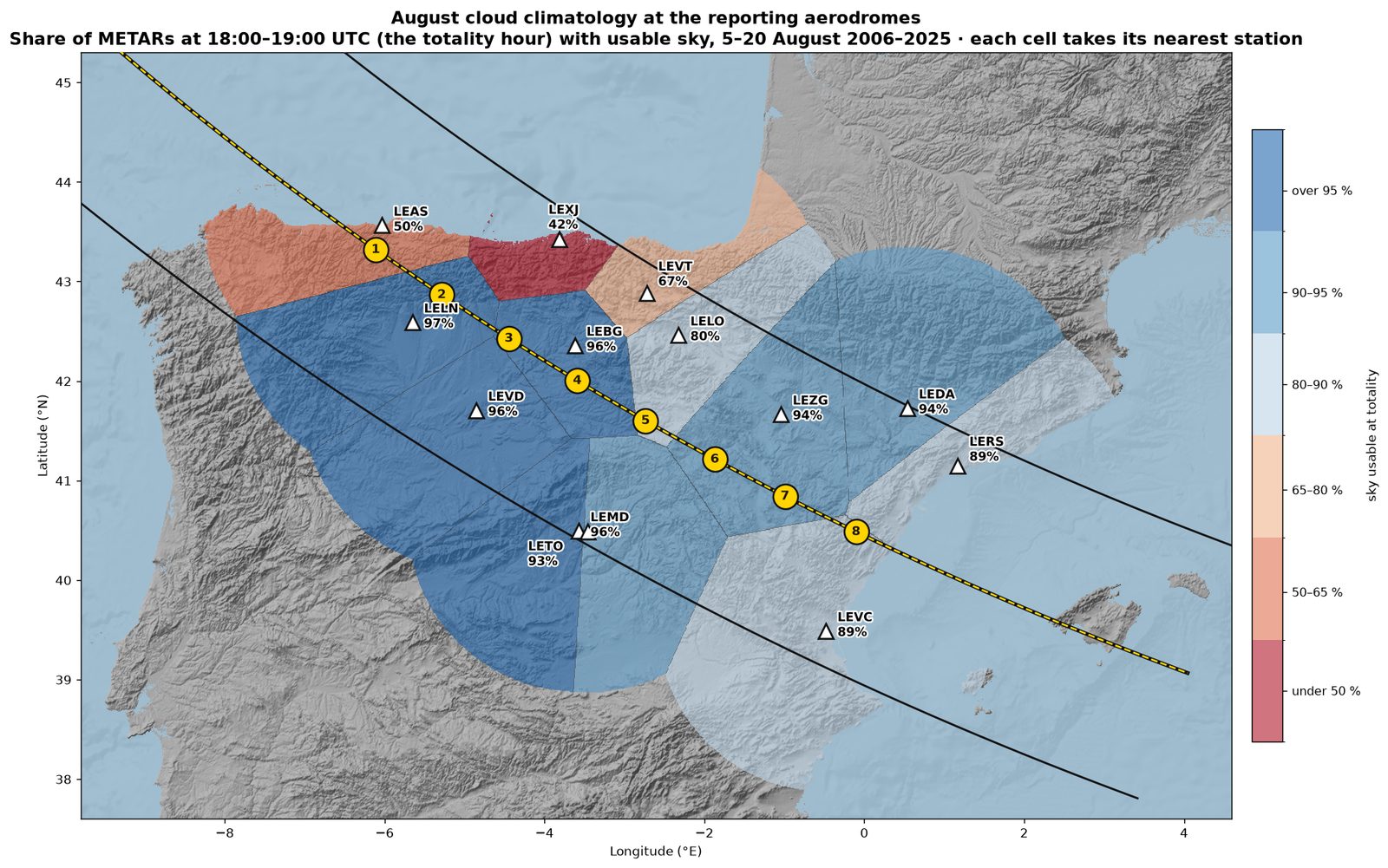
Geometry and climate point in opposite directions. Slice 1 has the longest totality and the highest sun, and Asturias is clouded out half the time (Santander, 58 %). Over the mountains onto the meseta it flips — Burgos 96 %, León 97 %, Zaragoza 94 %. Nine extra seconds of totality roughly doubles the chance of seeing nothing.
For the Salinillas plan: the nearest stations are Vitoria at 30 km (67 %) and Logroño at 45 km (80 %) — the upper Ebro still catches Cantabrian cloud. Burgos, nearest both Lerma and Alto de Merendilla, is 96 %. The drive south-west buys better odds as well as more totality.
Full numbers for all thirteen stations
| Station | Clear/few | Scattered | Broken/OVC | Usable |
|---|---|---|---|---|
| LELN · León 43 km off centre · 88 obs | 81% | 16% | 3% | 97% |
| LEBG · Burgos 32 km off centre · 102 obs | 75% | 21% | 4% | 96% |
| LEVD · Valladolid 85 km off centre · 52 obs | 73% | 23% | 4% | 96% |
| LEMD · Adolfo Suárez Madrid–Barajas 142 km off centre · 45 obs | 78% | 18% | 4% | 96% |
| LEZG · Zaragoza 78 km off centre · 93 obs | 74% | 19% | 6% | 94% |
| LEDA · Lleida-Alguaire 147 km off centre · 36 obs | 92% | 3% | 6% | 94% |
| LETO · Madrid–Torrejón 137 km off centre · 105 obs | 73% | 20% | 7% | 93% |
| LEVC · Valencia 114 km off centre · 136 obs | 67% | 22% | 11% | 89% |
| LERS · Reus 115 km off centre · 153 obs | 65% | 24% | 11% | 89% |
| LELO · Logroño-Agoncillo 99 km off centre · 65 obs | 63% | 17% | 20% | 80% |
| LEVT · Vitoria 121 km off centre · 163 obs | 48% | 18% | 33% | 67% |
| LEAS · Asturias 25 km off centre · 175 obs | 32% | 18% | 50% | 50% |
| LEXJ · Seve Ballesteros-Santander 120 km off centre · 156 obs | 27% | 15% | 58% | 42% |
On the day
↑ contentsClimatology chooses the region. These choose the spot, in the last 48 hours. Current observations are on the live dashboard; the list below is reference only.
What to watch, and when. T−10 to T−3 days: ECMWF and AEMET medium-range — treat as a regional steer only. T−30 hours: the first TAFs covering eclipse evening appear, on the 11th. These are real aviation forecasts of cloud base and amount, and they are the best worded guidance you will get. T−6 hours and inside: stop reading forecasts and watch Meteosat rapid-scan imagery, refreshed every five minutes, plus the hourly METARs below. That is how the 2024 Texas chasers made their final moves. With totality at 20:28–20:32 local, August convection over the meseta is normally decaying by then.
Aerodrome links — 15 stations, METAR, TAF, Windy, Yr
| Aerodrome | Live observations & forecast |
|---|---|
| LEAS · Asturias Ranón · 25 km off centre | METAR TAF Windy Yr |
| LELN · León La Virgen del Camino · 43 km off centre | METAR TAF Windy Yr |
| LEBG · Burgos Burgos · 32 km off centre | METAR TAF Windy Yr |
| LEVD · Valladolid Valladolid · 85 km off centre | METAR TAF Windy Yr |
| LEXJ · Seve Ballesteros-Santander Santander · 120 km off centre | METAR TAF Windy Yr |
| LEVT · Vitoria Alava · 121 km off centre | METAR TAF Windy Yr |
| LELO · Logroño-Agoncillo Logroño · 99 km off centre | METAR TAF Windy Yr |
| LEZG · Zaragoza Zaragoza · 78 km off centre | METAR TAF Windy Yr |
| LETL · Teruel Teruel · 51 km off centre | METAR TAF Windy Yr |
| LECH · Castellón-Costa Azahar Castellón de la Plana · 20 km off centre | METAR TAF Windy Yr |
| LEVC · Valencia Valencia · 114 km off centre | METAR TAF Windy Yr |
| LERS · Reus Reus · 115 km off centre | METAR TAF Windy Yr |
| LEDA · Lleida-Alguaire Lleida · 147 km off centre | METAR TAF Windy Yr |
| LEMD · Adolfo Suárez Madrid–Barajas Madrid · 142 km off centre | METAR TAF Windy Yr |
| LETO · Madrid–Torrejón Madrid · 137 km off centre | METAR TAF Windy Yr |
Cloud, as it is now
The only tool that matters in the final hours. Rapid-scan covers Europe every five minutes.
EUMETView AEMET satellite Sat24 Spain Zoom EarthDays out
Prefer high-resolution models near the day: AROME and ICON-D2 resolve afternoon convection that global models smear.
Windy (ECMWF/AROME) AEMET forecast VentuskyChaser resources
Cloud climatology and prospects written for this particular eclipse, by people who do this for a living.
Eclipsophile 2026 NASA path data Xavier Jubier map